

Tall Tower Wind Monitoring Technology Developed
More than twenty years of real world lessons learned are being brought to bear in WeatherFlow’s Bolton office, as…
Tall Tower Wind Monitoring Technology Developed Read More »
More than twenty years of real world lessons learned are being brought to bear in WeatherFlow’s Bolton office, as…
Tall Tower Wind Monitoring Technology Developed Read More »
December 21, 2010. Suitland, Maryland. NOAA/NESDIS researcher Dr. Ken Pryor is using Weatherflow observations to help verify his newly developed microburst forecasting technique, in which he uses GOES Satellite imagery to estimate surface wind speeds emanating from convection. On several recent occasions, WeatherFlow observations have verified the estimates generated by his algorithm. Two such events occurred on
Microburst Research uses WeatherFlow Data Read More »
November 15, 2010. Fort Belvoir, Virginia. With a relationship dating back before the attacks of September 11, 2001, WeatherFlow and the Defense Threat Reduction Agency (DTRA) recently renewed a contract that provides for a real-time feed of WeatherFlow observational data to DTRA. WeatherFlow sites, installed to complement existing National Weather Service observations, are extremely well positioned to
DTRA Contract Renewed Read More »
November 10, 2010. Bolton, Massachusetts. In conjunction with its Wind Energy Mesonet initiative, WeatherFlow recently took delivery of its first operational SODAR unit. Manufactured by industry leader Second Wind, the Triton unit is one of the most frequently used profilers in the wind energy industry and will continuously sample the wind characteristics of the lower atmosphere up to 200m. Designed
First SODAR Fielded Read More »
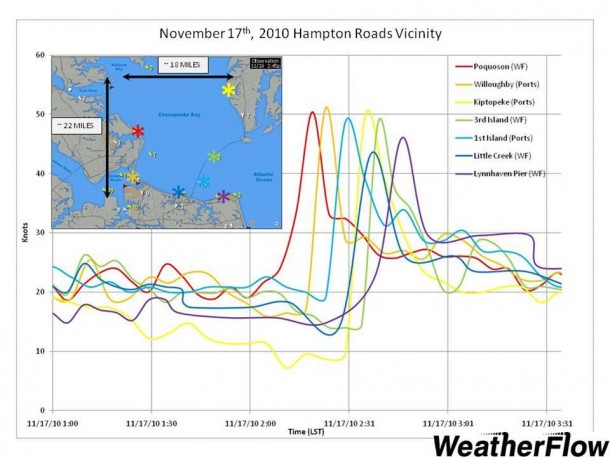
October 29, 2010. Chesapeake Bay. A three year effort by the Chesapeake Bay Inundation Prediction System (CIPS) concluded recently, with WeatherFlow observation and model data having played a major role. The CIPS team, composed of scientists and analysts from the National Weather Service, several academic institutions, and WeatherFlow, produced an end-to-end prototype tidal flooding prediction
CIPS Reaches Milestone Read More »