
Recomended for ages 12+
We all know that the warmest time of the day is in the afternoon when the sun is high in the sky and sending down its strongest rays. Right? Well, actually that isn’t always the case. On some days, you may find that the temperature actually gets colder in the afternoon. But how can that be? This can happen if a cold front comes through your area. In this activity, you will learn what a cold front is, how it affects you and how you can use maps and observations to find one yourself.
What is a cold front?
To understand cold fronts we first have to talk about air masses. If a big blob of air sits for a while over a spot on the Earth, it will start to become like the land or water below it, just like if you held your hand over a block of ice it would feel colder and colder. Air acts in the same way. So if a big blob, or mass, of air sits over the Canadian Plains for example, it will become cold and dry. If a different mass of air sits over a Tropical Ocean, it will become warm and moist. If these two air masses start to get pushed together, a boundary begins to form between them because they are so different from each other. That boundary is called a cold front.
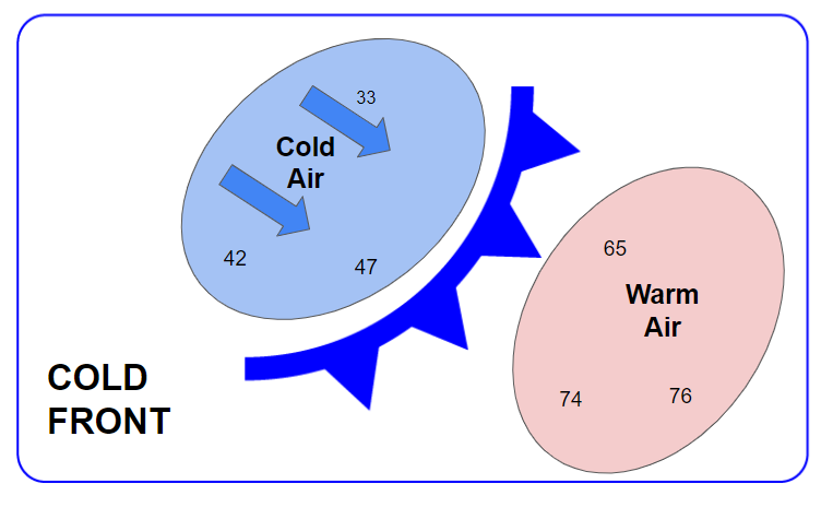
Imagine you were looking down at the earth from space. In a similar top down view, the graphic below shows where the warm air and cool air would sit around a cold front. Think back to a time when you’ve seen a meteorologist reporting about the weather on the news.. A cold front is represented on a map as a blue line with triangles. The point of the triangles shows the direction the cold air is moving.
Now, we’ll learn about finding air masses. You can learn how to do this activity by watching this video or following the directions below.
- Open the National Weather Service Digital Viewer by clicking here or pasting this link into your browser: https://digital.weather.gov/
- Select “Maximum Temperature” in the second box.
- Look at the temperatures that are shown on the map. The color key is at the bottom. The warmer temperatures are red, the colder temperatures become progressively dark blue. Can you see warm air masses and cold air masses?
- Now look for areas on the map where the temperatures are changing very quickly. This is likely where the cold front is.
- Check to see if you are right by going to https://www.wpc.ncep.noaa.gov/#page=ovw. The first map will show where the cold fronts are currently sitting.
Were you able to find a cold front? If not, try another day. We don’t see cold fronts every day and some days, especially in the summer, they are not very strong.
Cold Fronts Bring Clouds, Precipitation, Winds, and Cold Air
Knowing where a cold front is can be extremely important, because as these two air masses collide we can get some dramatic weather. The two different air masses clash at what is called the frontal boundary, just like two armies at war. In fact, that is where the name front came from. The cooler, dry air is more dense and stays closer to the ground as it pushes under the warm, moist air, and causes it to rise, kind of like a bulldozer. This can cause clouds, rain, and sometimes even violent thunderstorms to grow. So when a front arrives, you frequently need an umbrella. We can also often see strong and rapidly shifting winds as the two air masses collide.
Let’s see if we can find these weather changes on a map.
- Return to https://digital.weather.gov/
- Change the 2nd box to “Sky Cover”. This will now show you the forecast for the amount of clouds. The darker the color the more likely that there will be clouds.
- Do you see a correlation between the location of the cold fronts and the clouds?
- Now change the 2nd box to “Precipitation Potential Index” . The darker the green the more likely rain is to fall.
- Do you see a correlation between the cold front and the chance of precipitation?
- Now change the 2nd box to “Wind Speed” This will now show the forecast for wind.
- Do you see a correlation between the cold front and the strongest winds? Where are they in relation to the front? Many times we find that they are in the coldest air behind the front.
Cold Fronts Move East
Cold fronts generally move in an Easterly direction across North America. As they move the clouds, rain, and winds move along with them.. Let’s see if we can see the movement of the front on forecast maps.
- Return to https://digital.weather.gov/ and select “Max Temperature”.
- Find the slider on the upper right that shows future days. As you move it to the right it will show the forecast map for that day.
- Slide the bar to the right by one day and take a look at the map. Did the cold air mass start to shift to the east? Keep shifting it forward and watch how the cold and warm air masses move.
- Now try the same thing with the “Precipitation Potential Index” and the “Wind Speed” and see if these shift eastward with the front.
Using Past Weather Observations to Find a Cold Front
You can also use weather observations from a Tempest Weather Station or any other recording to find when a cold front came through.
- Go to TempestWX.com and select “Map” at the top.
- Look at the map that shows where all the Tempest stations are located. Pick a station that is behind or west of the cold front.
- Click on the station marker and the station observations will pop out at the right.
- Click on the station name to bring up the observations.
- Start by clicking on the temperature. This will bring up a graph that shows all the temperature readings from the past week. Scroll back and see if you can find where the line drops quickly showing cold air moving in.
- Now go and check the tracings for wind and rainfall to see if you can find that they all started to change when the front was coming through.
- Another way to check for a front is to look at the pressure tracing. A cold front will lie in what is called a trough of low pressure. It will look like “V” on the pressure tracing. Check the tracing to see if you can find a “V” and if that correlates to the time of a cold front.
From this activity, you have gathered some of the tools that you need in order to start learning to understand a weather forecast. You can use your own Tempest Weather Station, or use the map to watch a station, to find when a cold front is moving through a specific area. This skill can definitely come in handy, especially when you want to know when to wear a coat or carry an umbrella!