
Hurricane Development and Decay
Atlantic hurricane season falls from June 1st to November 30th every year, and with August well underway, what better time is there to write a post on the life cycle of a hurricane? Whether you are a kid on summer vacation or one of our avid adult sailors/kiters/windsurfers/weather enthusiasts, this post will give you a strong foundation on what a hurricane is, how it develops, and how it dies out. And if you haven’t watched the intro video to this topic on our YouTube, make sure to check it out here: Weather Word of the Week YouTube Playlist.
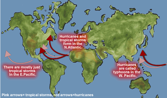
According to the American Meteorological Society, a hurricane is a “tropical cyclone with 1-min average surface (10 [meter]) winds in excess of 32 [m/s] (64 knots) in the Western Hemisphere (North Atlantic Ocean, Caribbean Sea, Gulf of Mexico, and in the eastern and central North Pacific east of the date line).”Hurricanes do not appear out of thin air and instead go through a generation and decay process that can be thought of as a life cycle. The stages of this cycle are organized based on the strength of the maximum 1-minute sustained surface winds in the system and go as: tropical disturbance, tropical depression, tropical storm, hurricane, and post-tropical cyclone.
Lifecycle of a Hurricane
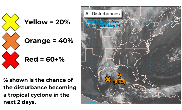
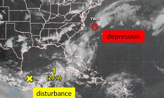
Now despite hurricanes being some of the most destructive natural phenomena on the planet, each one starts out as a small organized mass of tropical thunderstorms with a hint of cyclonic circulation and winds less than 20 knots (kts)—this is known as a tropical disturbance, and it is the first stage in the life cycle of a hurricane. Tropical disturbances often form in the tropical Atlantic Ocean between the coast of northwestern Africa and the east coast of the Americas; this area is called the Main Development Region because though disturbances can and do form outside of this region, the majority of disturbances originate here. The National Hurricane Center (NHC) indicates tropical disturbances as “X”s with a number colored yellow, orange, or red based on the probability that they will develop into a tropical cyclone in the next 2 days. Their number differentiates them from other disturbances in the same ocean basin.
Tropical disturbances traditionally originate over tropical waters because they derive their energy from ocean water that is warm enough to consistently evaporate into the air, rise up through the atmosphere, and then cool and condense to form clouds. Sea surface temperatures in the tropics during hurricane season are in the 80°s (°F), which allows this evaporation to take place much easier in the tropics than anywhere else in the Atlantic Ocean basin.
Cumulus clouds from the evaporation grow into cumulonimbus clouds which are the basis of thunderstorms. Thunderstorm updrafts and downdrafts assist in continued evaporation at the sea surface so that more clouds develop and the tropical disturbance grows into a weak (but building) localized system. When the disturbance has developed to the point that the winds flowing around it have reached 20-34 kts, then it is called a tropical depression and has reached the second stage in its life cycle. Tropical depressions will appear as an open red circle with a written out number (i.e. “one” or “two”) to identify the system on a map.
As the winds continue to strengthen and the thunderstorms grow, the tropical depression can build into a tropical storm. A tropical storm will have winds between 35 and 64 kts, and this is the third stage in a hurricane’s life cycle. When a depression is upgraded to a tropical storm, it is highlighted as an empty red circle with two tails and receives a name for identification instead of a number (for example, tropical depression ONE can turn into tropical storm Eta).
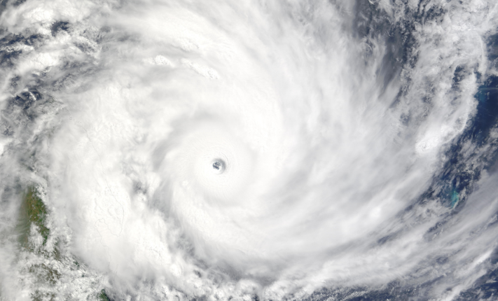
The tropical storm stage is often when an “eye” first becomes visible and when the storm’s organization is clearly defined. By organization, the key features I mean are rain bands, outflow/overcast, and a developing or already developed eye and eyewall. Let’s go into a little more detail on all of these features.
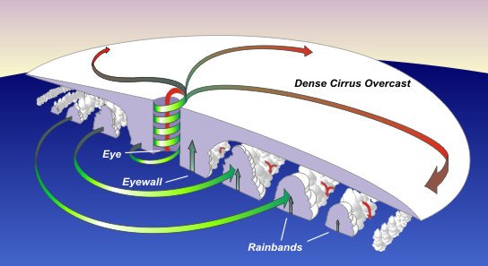
Rainbands radiate outwards from the center of rotation and are localized pockets of intense convection producing heavy rainfall. While the sketch above depicts the “pocket” aspect of rainbands, it also makes it seem like the rainbands are completely circular around the storm, like levels on a target, but that is not the case. More typical are rain bands radiating outwards like spiral tails away from the eye as opposed to a circle around the eye; in the radar image above, you can see the rainbands as the yellow and red sections of the storm indicating heavy rainfall.
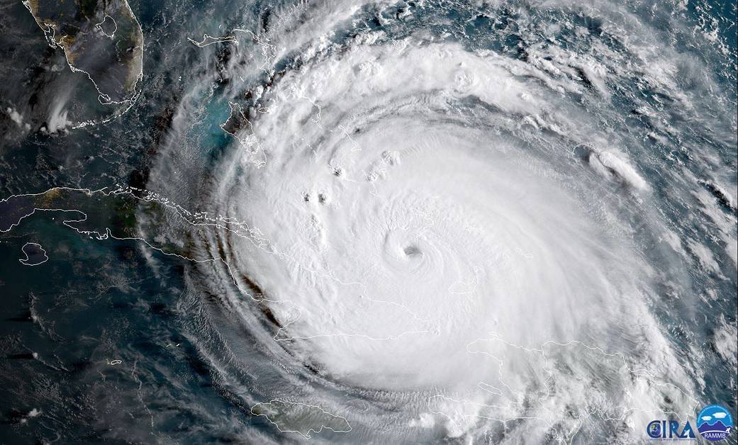
Additionally, there will be outflow (sometimes referred to as cirrus overcast) radiating outwards from the top of the storm. This can give an almost blanket-like appearance to satellite images by covering the rainbands and lower-intricacies of the storm. As with the NOAA satellite image of Hurricane Irma below, without a radar image, it is difficult to discern the rainbands closest to the eye of the storm due to the outflow cirrus clouds. You can, however, make out some overshooting tops of cumulonimbus clouds that have pushed through the cirrus outflow cap in the northwest sector of the storm, and are likely to indicate the presence of a rainband.
Eyes/eyewalls are also distinguishing features of tropical storms and hurricanes. An eye is the center of rotation where dry air is actually sinking as opposed to rising—meaning no clouds are present—and wind speeds are less than 20 kts. Surrounding the eye is what’s known as the eyewall, which is a thick line of clouds with some of the strongest winds in the storm system as well as central portions of rain bands. Traditionally, a tropical cyclone “makes landfall” when the eye first comes over land, not when the rainbands or cirrus outflow come over land. Nonetheless, damage from tropical cyclones certainly begins with the onset of the outer expanses of the storm that arrive on land before the eye.
Now back to the life cycle of a hurricane… Many tropical cyclones only reach the stage of tropical storm before they decay and never become a hurricane. Tropical storms, however, can still cause damage to large regions, primarily in the form of excessive rainfall that leads to dangerous flooding.
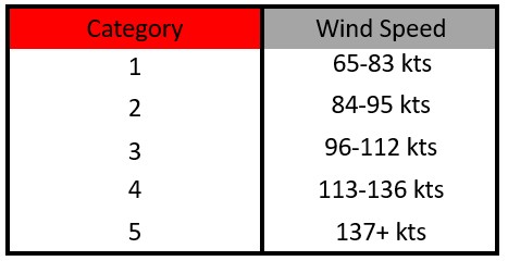
If a tropical storm is able to continue intensifying, though, then its central pressure will drop, its circulation will become more organized, and its winds will increase to 65+ kts, at which point it is classified as a hurricane. On a map, hurricanes appear as a filled-in red circle with two tails and the same name they had as a tropical storm. Hurricanes are further classified into Categories, again, based on their wind speed, using the Saffir-Simpson Hurricane Wind Scale. See the table below for the breakdown between Category 1 and Category 5 storms.
Categories 3, 4, and 5 are known as major hurricanes, and these are the ones that get their names retired. The animation linked here from the Comet Project and highlighted on the National Hurricane Center’s website shows a modeled depiction of the damage that can occur based on each category.
Hurricane Decay
In my opinion, the best way to explain tropical cyclone decay is with a rechargeable battery analogy. For our tropical cyclones, our battery (and thus, source of energy) is a warm ocean that evaporates lots of water into the atmosphere. As long as the storm is over warm ocean water, then its battery will be continuously charged. However, when the source charging the battery—the warm ocean—is not present, then the tropical cyclone cannot charge its battery, and therefore, it can only stay alive until the energy in its current battery runs out. Often times this loss of charging source occurs when a storm makes landfall and is no longer over the ocean.
Over land, the trees, houses, hills, and any non-flat feature disrupt the flow of the storm, which assists in depleting the storm’s battery since the winds use energy trying to blow over barriers and overcome more friction. And without more moisture being added to the storm system from warm oceans, storms over land are forced to use up their battery and expel their moisture without it being replaced. It is critical to note, though, that decaying storms still cause a plethora of damage because they still have a full battery’s worth of energy to expel, even if they are not re-charging.
Storms in the Gulf of Mexico that make landfall often begin decaying as they move northeast over the inland southeastern and mid-Atlantic states. Storms that make landfall on tropical islands or even the peninsula of Florida, however, can momentarily decay and then re-strengthen if they pass over the land and enter the Gulf of Mexico; these storms ultimately make two landfalls: one on the Florida peninsula and a second somewhere along the Gulf Coast. Hurricane Katrina is an example of a hurricane that made 2 landfalls. In 2005, Katrina hit southern Florida as a Category 1 storm but passed over the peninsula into the Gulf of Mexico, where it grew and made a second landfall in Louisiana as a Category 3 storm.
When a storm moves out of the tropics and weakens to the point where the winds at the surface are consistently weaker than the winds at the top of the storm (what is called a warm- to cold-core transition), then the tropical cyclone becomes a post-tropical cyclone, the final stage in the life cycle of a tropical system.
Fun Fact
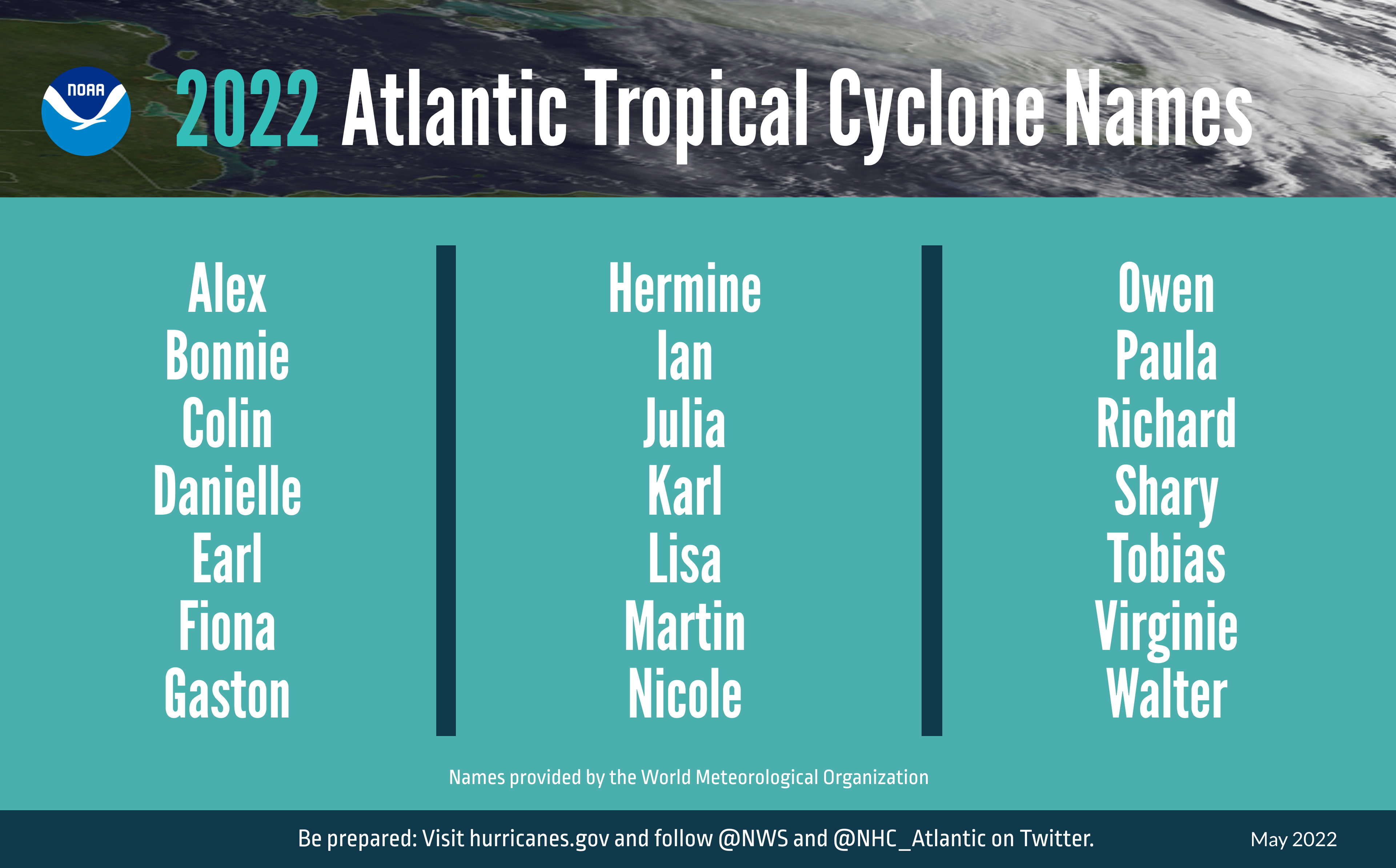
Each year, a list of names is used for naming all the tropical storms and hurricanes of that season. There are six lists of names, and each list repeats once every six years. If a storm becomes a major hurricane, then that name gets retired, and a new name replaces it on the list.
 Learn More
 Learn More
Check out these great websites where the life cycles of tropical storms and their characteristics are discussed.
Smithsonian Ocean: https://ocean.si.edu/planet-ocean/waves-storms-tsunamis/hurricanes-typhoons-and-cyclones
Northern Vermont University online chapter on hurricanes: https://apollo.nvu.vsc.edu/classes/met130/notes/chapter15/index.html
NOAA’s Saffir-Simpson page and model video: https://www.nhc.noaa.gov/aboutsshws.php
The Weather Channel: “Tropical vs. Non-Tropical; What’s the Difference”: https://weather.com/storms/hurricane/news/hurricane-hermine-transition-impacts-forecast-post-tropical
Stay up to date on current tropical weather by visiting the National Hurricane Center’s website: https://www.nhc.noaa.gov/
Have more hurricane questions?
Leave a comment or send us an email about any questions you still have about hurricanes, and we’d love to answer them for you. If we get enough interest, we just might have to make another post or video with the answer!