
Poquoson, VA – WeatherFlow’s network of weather stations captured the passage the nation’s first hurricane since Superstorm Sandy. Hurricane Arthur made landfall near Fort Macon, NC and passed through the Outer Banks of North Carolina exhibiting surface wind speeds of a Category 1 tropical storm on the Saffir-Simpson Hurricane Scale.
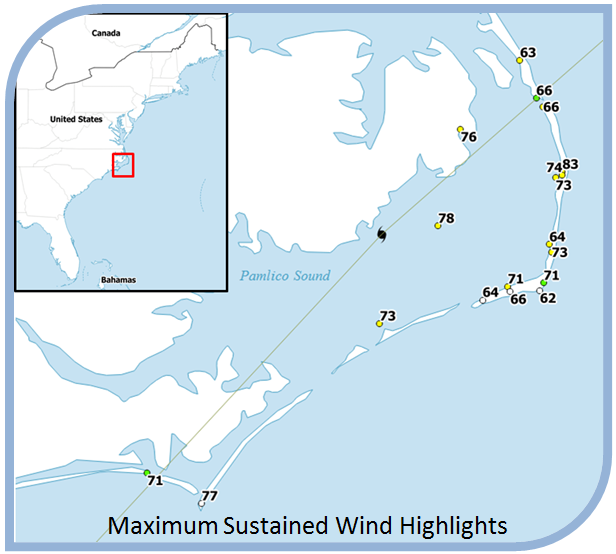
The dense network of weather stations operated by WeatherFlow and its partners allowed for a detailed footprint of the storm to be recorded. In fact, WeatherFlow and its hurricane monitoring partners recorded 18 of the 25 strongest sustained wind speed measurements. WeatherFlow’s KHK Resort station, 20 miles north of Cape Hatteras, reported the highest recorded maximum sustained wind speed of 83 mph in the eye wall at 3:53am on July 4th. Other notable maximum sustained wind speeds were 78 mph at Pamlico Sound (another WeatherFlow station) and 77 mph at the NOAA station on Cape Lookout.
Similar to the sustained wind speed measurements, WeatherFlow and its hurricane monitoring partners recorded 18 of the 25 strongest wind gusts. NOAA’s Cape Lookout station reported the strongest gust of 101 mph at 11:20pm on July 3rd as the hurricane made landfall a few miles to the east. Three other WeatherFlow locations reported 99 mph gusts; Pamlico Sound, Ocracoke and Stumpy Point.
Of the WeatherFlow partner deployable networks, the University of Florida’s Coastal Monitoring Program towers stationed near Cape Hatteras reported maximum sustained wind speeds of 66 and 62 mph.
WeatherFlow’s data is used extensively by the insurance industry for loss assessment and policy triggers. It is also used to support NWS operations during storm passage, emergency response, and post-storm hurricane analysis and validation.
About WeatherFlow:
WeatherFlow, Inc. owns and operates a proprietary network of high-quality weather observing stations including the custom-designed WeatherFlow Hurricane Network. Along with data from other providers, WeatherFlow distributes its network data to users through a suite of tailored products and services. WeatherFlow also produces high resolution gridded forecasting and analysis products down to scales of 200m. For more information, visit WeatherFlow.com.
Copyright 2014, WeatherFlow, Inc.